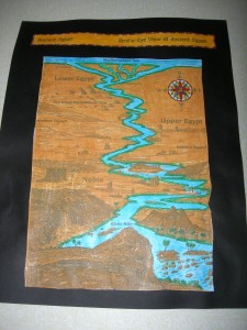
 Whenever you study a country, you ought to color a map of it, no matter what age you are. It helps you to remember the shape of the country, the rivers, and whatever else is on the map, like the major cities. I love this particular map of Egypt because it has some cartoon-like cultural stuff on it. Kids love it, and they can see where the pyramids are located, where Abu Simbel is (I walked around there!), and where Upper and Lower Egypt are (in opposite locations than you would think).
We colored the Nile River blue first. Then we put green along the river, because I’ve been on the Nile River, and it’s green right next to the water, where there are palm trees. The rest of the land is sand dunes. So the children colored the rest of the land light brown or yellow to represent the sand. Having a strong grasp of how Egypt looked, the kids were ready to make Egypt cookies.


